Riga, Kemeru iela 6 and Baseina iela 5
The Project
The 2 lots, 7000m2 total, are located very close to Kalnciema iela, a road connecting Riga City Center with Ulmana Gatve an express way to Riga Airport and Jurmala www.jurmala.lv, a Baltic Sea Side Resort. The Elefants Hotel is directly located next to the lots.Very close, at a distance of 150meters is the Zasulauks Railway Station with connections to Jurmala, a 15 min trip and City Center, a few minutes by train. Panorama Plaza, www.panoramaplaza.lv developed by Mesa Construction of Ankara, Turkey and Shopping Center Spice www.spice.lv are also a few walking minutes away.
BASEINA STR 5
LANDPLOT AREA (EXCLUDING AREA IN RED LINES) - 1612 m²
BUILDING AREA - 590 m²
MAX TOTAL FLOOR AREA (BRUTTO) - 1770 m² (590 X 3 FLOORS)
REALISTIC * TOTAL FLOOR AREA - 1475 m² (590 X 2,5 FLOORS)
DRIVEWAYS (INCLUDING SLOPE) - 120 m²
GREENERY AREA- 902 m² (min** 708 m²)
NUMBER OF APARTMENTS ~ 22
UNDERGROUND PARKING - 16 LOTS (min 11)
KEMERU STR 6 SUMMARY
LANDPLOT AREA (EXCLUDING AREA IN RED LINES) - 4134 m²
TOTAL BUILDING AREA -1516 m²
MAX TOTAL FLOOR AREA (BRUTTO) SUMMARY - 4548 m²
REALISTIC * TOTAL FLOOR AREA – 3790 m² (1516 X 2,5 FLOORS)
DRIVEWAYS (INCLUDING SLOPE) - 315 m²
GREENERY AREA - 2303 m² (min** 1819 m²)
NUMBER OF APARTMENTS SUMAMRY ~ 57
UNDERGROUND PARKING - 33 LOTS (min 29)
KEMERU STR 6 (BUILDING 1)
BUILDING AREA - 1010 m²
TOTAL FLOOR AREA (BRUTTO) - 3030 m² (1010 X 3 FLOORS)
REALISTIC * TOTAL FLOOR AREA – 2525 m² (1010 X 2,5 FLOORS)
NUMBER OF APARTMENTS ~ 38
KEMERU STR 6 (BUILDING 2)
BUILDING AREA - 506 m²
TOTAL FLOOR AREA (BRUTTO) - 1518 m² (506 X 3 FLOORS)
REALISTIC * TOTAL FLOOR AREA – 1265 m² (506 X 2,5 FLOORS)
NUMBER OF APARTMENTS ~ 19
* the number of floors for new buildings in
protected construction areas should be
determined depending on the number of
building floors established in particular area.
This is decisive over what is permitted in
Riga’s development plans. The new buildings
should be formed by taking into account a
historically established technical indicators
(parametres) in a particular area as well.
It means that 3-rd floor should be formed
as attic with slope roof , and 3-rd floor
area will decrease approximately for an
half in that case.
** 40% of total floor area
LOCATION OF LANDPLOTS

Investigation goal is to find out possibilities and
restrictions of landplot’s development.
Both landplots are located in building protection
zone where most of buildings are private houses or
two-story historic wooden housing.
A lot of existing trees and complicated shape of
Kemeru str 6 landplot determine the potencial
location of the new buildings, but on the other hand
the trees are a huge benefit for
further development of residential buildings and will
become an added value to property. Trees should be
inspected before starting design a buildings.


TOPOGRAPHY 2020


UNDER DEVELOPMENT „RTIAN” 2019-2030 ( RIGA CITY DEVELOPMENT PLAN AND BUILDING RULES) RESEARCH.


BUILDING DENSITY AND FREE TERITORY (LANDSCAPING AND GREENERY)
Maximum building density* - 30%, minimum free (greenery and landscaping) area** - 40%
*Building density is an area of all building volumes located in certain landplot. It is expressed as a
percentage – the ratio between the total building area (projection on ground level) of the all buildings
and the area of the landplot.
**minimum free teritory index is percentage between all floors area sum and free (not built) area. Car
parking and drive ways are not included in the free teritory area. Bicycle roads, shelters, pedestrian
walkways, sport activities and children playgrounds can be included in free teritory area.
The theoretically reachable maximum building density :
Baseina str.5 landplot - 546 m² (1820*m² x 0.3**)
Kemeru str.6 landplot - 1251.6 m² (4172*m² x 0.3**)
Maximum total area (brutto):
Baseina str.5 landplot - 546 m² x 2,5 (max allowed number of floors)=1365 m² (number of app.17)
Kemeru str.6 landplot - 1256.1 m² x 2,5 (max allowed number of floors)=3129 m² (number of app.39)
Minimum free teritory:
Baseina str.5 – 1365 m² x 0.4***= 546 m²
Kemeru str.6 – 3129 m² x 0.4*** = 1251.6 m²
* landplot area
** maximum allowed density 30%
*** minimum free teritory - 40% of total area
PARKING.
The number of parking places and bike racks may differ depending on building function.
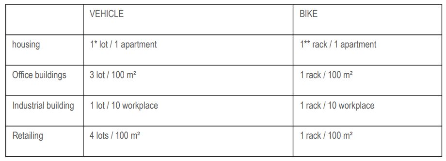
* the number of parking lots may be reduced to 0,7 if, within a radius of300 m, there is a public transport stop with a transport
frequency of 1 times every 5 minutes in peak hours.
** 90% – covered premises, 10% – near the entrances
At maximum building density , the necessary car and bicycle parking space for housing would be a minimum:
- min 17 parking lots ( including driveways) and 17 bike racks for Baseina str.5 landplot
- min 39 parking lots ( including driveways ) and 39 bike racks for Kemeru str 6 landplot .

UNDER DEVELOPMENT „RTIAN” ( RIGA CITY DEVELOPMENT PLAN AND BUILDING RULES).
LANDPLOT DEVELOPMENT RESEARCH / BASEINA STR. 5 AND KEMERU STR. 6, RIGA, 2019 27
BUILDING LOCATION AND PARAMETRES. SCHEME 1
BASEINA STR 5
LANDPLOT AREA - 1820 m²
MAX BUILDING AREA* - 546 m²
MAX TOTAL FLOOR AREA (BRUTTO) - 1365 m² (546 X 2.5 FLOORS)
DRIVEWAYS AND PARKING - 515 m²
GREENERY AREA- 759 m² (min** 546 m²)
NUMBER OF APARTMENTS ~ 17
PARKING - 17 LOTS (MIN 17)
KEMERU STR 6 SUMMARY
LANDPLOT AREA - 4172 m²
TOTAL MAX BUILDING AREA* -1252 m²
MAX TOTAL FLOOR AREA (BRUTTO) SUMMARY - 3130 m²
DRIVEWAYS - 1040 m²
GREENERY AREA - 1880 m² (min** 1252 m²)
NUMBER OF APARTMENTS SUMAMRY ~ 39
PARKING - 39 LOTS (min 39)
KEMERU STR 6 (BUILDING 1)
BUILDING AREA - 740 m²
TOTAL FLOOR AREA (BRUTTO) - 1850 m² (740 X 2.5 FLOORS)
NUMBER OF APARTMENTS ~23
KEMERU STR 6 (BUILDING 2)
BUILDING AREA - 512 m²
TOTAL FLOOR AREA (BRUTTO) - 1280 m² (512 X 2.5 FLOORS)
NUMBER OF APARTMENTS ~ 16


|
|
|
| Google Map |
